


-
>
-
New 'How to get Here' leaflets for your organisation
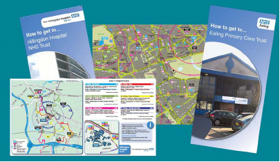
17/07/2009A key part of any travel plan is promoting the local transport routes in your area. For travel plan coordinators, putting together such information and producing detailed maps in an accessible format can often be beyond their skills or budget. To make this process easier, WestTrans has undertaken a project to map the entire West London area in a user-friendly style (similar to that used by the ground-breaking Legible London project in central London).
With this mapping now produced, and specially commissioned template leaflets available in a range of sizes from pocket sized maps to A1 sized wall-charts, whatever the size of your organisation, you can now take advantage of this offering and encourage both your staff and visitors to travel sustainably.
To get your site specific leaflets, you will need to have a travel plan in place at your organisation, and if your travel plan is voluntary, aside from the costs we've saved you in commissioning the mapping and leaflet templates, you will also receive a further 50% discount on printing costs through our match funding.
Organisations with travel plans produced as part of planning permission or obligations can also take advantage of this offering but will have to pay the full costs of printing and any extra alterations outside of the normal template.
The maps include all local cycle, train, tube and bus routes as well as isometric circles to show walking times for pedestrians.
See below for a downloadable example.
Further InformationNeasden Temple Wallchart (.pdf, 1339Kb)
-
-


©2024, WestTrans
Perceval House
4th Floor NE
Ealing Council
14-16 Uxbridge Road
Ealing
W5 2HL
Perceval House
4th Floor NE
Ealing Council
14-16 Uxbridge Road
Ealing
W5 2HL